
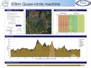
A screen shot of the tool developed for FCC civil engineering studies.
This tool offers a (very large) set of parameters and geological data such as soil composition, hydrography, environmental and sociological constraints and programmable risk factors data. You play with them – key in a tilt of, say, one percent or move points north or south or put the whole thing deeper underground – and the tool gives you a detailed profile of tunnels, shafts, access points and their respective location in the rock. It was commissioned by the Future Circular Collider (FCC) study to assess the feasibility, cost and realisation risks associated with different tunnel layouts of a large, circular collider with a perimeter in the order of 100 kilometres, be it proton-proton, electron-positron or electron-proton collider. It was developed over a few months by engineering design company Arup and it could come in handy for the ILC as well.
The tool is a so-called Building Information Modelling (BIM) tool with a web-based user interface for interactive adjustments. Before it reached its current stage, lots of data had to be fed in, with geological data coming from French and Swiss sources, satellite imagery, topographical and street map information as well as details from geothermal drillings and environmentally sensitive areas like water reserves in a designated area some 100 kilometres around CERN. Once the moraine, molasse, limestone depths as well as of Lake Geneva were fed in, details about the different collider configurations were added.
“For FCC, we have already looked at around 20 different possible layouts for the collider, each with pre-defined shafts and injection points from LHC. When you move one thing, everything else shifts as well, and we can see at a glance whether the configuration would work or not,” explains John Osborne, civil engineer and head of the civil engineering side of Future Accelerators Studies at CERN. “A shaft with an access point on top of a mountain and the shaft going 500 metres down to the collider location is not the preferred option, for example!” Obviously, once a site deemed good by the tool is selected, a host of additional data information about the land, the underground and its use by man is needed before it can be classified as appropriate – but it’s a good first approach.
The ILC civil engineering team is now looking at adapting the tool for the linear collider. A lot of data about the geology of the possible Kitakami site already exists, though they’d have to study the compatibility of formats in detail.
The machine-detector interface and detector design groups recently suggested moving the planned interaction region (where electrons and positrons would collide) by 800 metres, which would allow vertical shafts that are easier for lowering high-tech detector equipment. That of course has consequences for the rest of the accelerator, which would have to shift by 800 metres as well. “The tool could make a scan around the shaft and tunnel points, we can give tunnels a maximum acceptable slope, and the tool lets us study different configurations for the access points,” says Osborne. It also highlights difficult areas, if for example caverns come dangerously close to rivers due to the changed layout. All ILC groups need to sit down and take a close look at the implications of any changes to the layout. With the ILC being at a stage where R&D concentrates on site-specific designs, the tool from the circular cousin could prove to be key.
FCC Study Leader Michael Benedikt from CERN concludes: “This is a perfect example of industry and fundamental research partnership and demonstrates the many possible synergies between accelerator R&D activities worldwide.”
Recent Comments